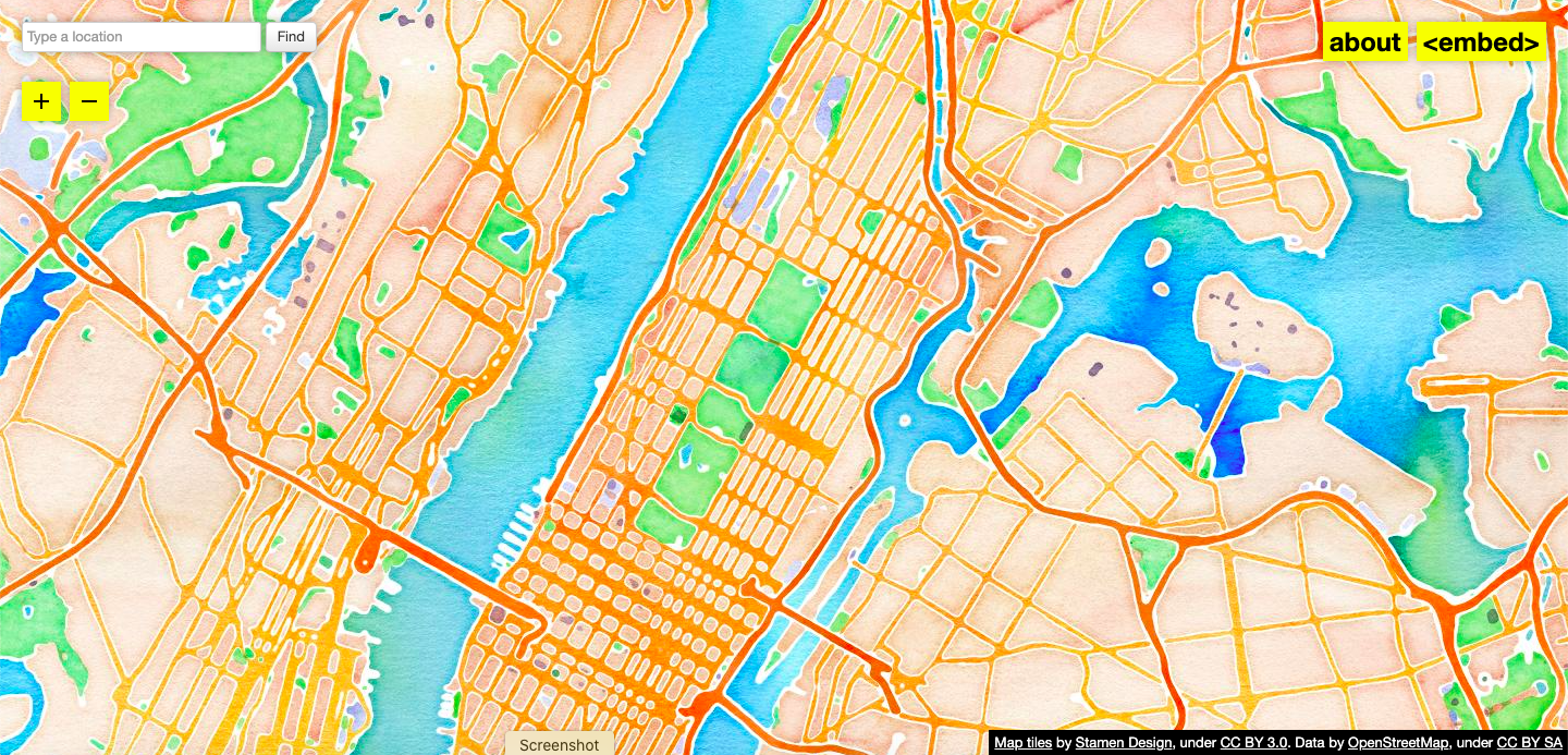
Watercolor Maptiles—a web-based, open-source mapping tool designed by Stamen Design that displays OpenStreetMap’s data with the hand-hewn textures of watercolor paint—has been acquired by Cooper Hewitt, Smithsonian Design Museum for its digital design collection. It is the Smithsonian’s first acquisition of a live website into its collections, consisting of over 56 million map tiles (separate png image files) and the underlying code. In addition to archiving these assets, a duplicate copy of the live site will be maintained as a Smithsonian version, prioritizing the free access and interactivity that is inherent to the work.
“Interactive digital works by their very nature subvert traditional museum collecting practices,” said Andrea Lipps, associate curator of contemporary design at Cooper Hewitt. “Watercolor Maptiles is itself a dynamic, living web-based map that is placeless; it exists on a browser and its assets are distributed across servers. By creating a duplicate version of the Watercolor Maptiles site and hosting it on Smithsonian Institution servers and domain, Cooper Hewitt has established a new acquisition model for the museum sector.”
“I wanted to make a kind of gesture in mapping that I hadn’t seen done before,” said Eric Rodenbeck, founding partner and creative director at Stamen Design. “Map making is always an expression of power as well as aesthetics. I wanted to show, not just say, that the choices mapmakers make are just that: choices, informed by ideology and agenda and all kinds of other factors. Maps occupy a special place in our information systems; they relate most closely to the physical world, so they’re a great conversation piece for issues of representation, power dynamics, technology, history. Everything gets wrapped up in maps if you look closely enough. There’s no such thing as a ‘neutral’ or ‘objective’ map; maps always leave something out for everything that they include.”
Launched by Stamen Design in 2012, Watercolor Maptiles is part of the design firm’s larger web-based cartographic project to create accessible, open-source tools that present public data in highly visual ways. Built on OpenStreetMap data, the maps are freely available for use and designed with public access as a fundamental goal. To explore and use the map, users can zoom in and out, enter a location into the geo search bar or just scroll around and create images for embedding into their own open-source projects.
Watercolor Maptiles breaks from traditional online cartography by emphasizing aesthetics at the same level as representational accuracy. The marks on the screen are based on real-world data, and the mapmakers have taken liberties with the rendering process to emphasize that the maps are the product of human–computer interaction, not the end result of faceless robotic activity. Water is rendered in blues mixed with turquoise and violet; green spaces are yellow, forest and muddy greens; terrain is a combination of peaches, browns and violet; motorways are oranges, reds and browns; buildings are lavender gray. The colors retain the texture of rough paper. A wet-wash technique results in darker tones where the pigment accumulated and disperses in lighter hues. The aesthetic recaptures the tactility and hand-hewn nature of physical maps, which are qualities that are often lost with digital maps, while being rooted firmly in the open data ethos and global nature of the OpenStreetMap project.
In addition to the over 56 million map tiles (individual 256 by 256 pixel png image files) and the underlying code, Cooper Hewitt has acquired printed maps made by Stamen Design when the website first launched. The museum has also generated extensive documentation around its efforts, including designer interviews; video documentation navigating the native site; and a substantial research dossier tracking all assets, changes and the acquisition process.
ABOUT COOPER HEWITT, SMITHSONIAN DESIGN MUSEUM
Cooper Hewitt is America’s design museum. Inclusive, innovative and experimental, the museum’s dynamic exhibitions, education programs, master’s program, publications and online resources inspire, educate and empower people through design. An integral part of the Smithsonian Institution—the world’s largest museum, education and research complex—Cooper Hewitt is located on New York City’s Museum Mile in the historic, landmark Carnegie Mansion. Steward of one of the world’s most diverse and comprehensive design collections—over 215,000 objects that range from an ancient Egyptian faience cup dating to about 1100 BC to contemporary 3D-printed objects and digital code—Cooper Hewitt welcomes everyone to discover the importance of design and its power to change the world. Cooper Hewitt knits digital into experiences to enhance ideas, extend reach beyond museum walls and enable greater access, personalization, experimentation and connection.
For more information, visit www.cooperhewitt.org or follow @cooperhewitt on Instagram, Facebook, Twitter and YouTube.
ABOUT STAMEN DESIGN
Stamen Design is an independent product development and communications agency founded by Eric Rodenbeck in 2001 and based in San Francisco. Stamen has attracted widespread attention for its innovative work in data visualization and maps for products, platforms, storytelling and the arts, for clients like the Dalai Lama, Facebook, the J Paul Getty, the Bill & Melinda Gates Foundation and many others. Stamen are the proud winners of the National Design Award for Interaction Design. The studio has been featured in design events internationally, including the Venice Biennale and the Victoria and Albert Museum in London. Stamen’s work is in the permanent collections of the Museum of Modern Art and Cooper Hewitt, Smithsonian Design Museum.
Information about Stamen Design may be found at www.stamen.com or follow @stamen on Twitter and @stamendesign on Instagram.
#
Image: Website, Watercolor Maptiles, 2012-15, live version 2020-21; designed by Eric Rodenbeck, Zachary Watson, Geraldine Sarmiento, Michal Migurski, and Nathaniel Kelso, Stamen Design; HTML, Javascript, CSS, and jpg image files: hand-painted watercolor textures applied to Mapnik tiles based on OpenStreetMap data using Python scripts and Photoshop.
